On April 7, I’m embarking on a personal adventure: a walk around Singapore. That’s 100 miles in 12 days. I do this for two reasons: To see and experience this wonderful country that I have 3x called home and to campaign for children in need.
I’m not much for publicizing or asking others to make donations. I do feel that this walk would be remiss if it was not used to promote change. If you would like to provide support, please consider making a donation to Caring for Cambodia or to the charity of your choice.

Click here to Donate!

Thursday, 17 April 2014

Day 7: Woodlands to Sembawang Park

Hey, today is my birthday! Its a late start today as I'm dropping the kids off at school, but its also a short walk. The plan is Woodlands to Yishun: about 7 miles. I take the MRT and I'm walking at about 9:30am. Its 83 already, so its going to be a hot one.

From the MRT terminal, I grab this great northern view of the Woodlands skyline:
Heading downstairs, I go east to make my start across the north side of Singapore. The scenery in this part of the country will be quite repetitive. That's because this is considered "the 'burbs". For the next 7 miles, I'm expecting to walk past HDB flat after HDB flat. And so far that's holding true:
HDBs along Woodlands Avenue 7
It's a pleasant walk. Each series of flats has a color scheme and some of them are quite lively. Many have open areas at the bottom where people can gather and create a sense of community. With regard to these walks, I particularly like using the covered  pathways in some developments since they keep me out of the sun.
This is nice but its also repetitive. After 3 miles I need more, so I decide to abandon my route and go rogue. I head north up Gambas Avenue to look for Woodlands Crescent Park, but I have to abandon the search due to a massive construction project. So instead, I turn east down a park connector which runs along a drainage line. I showed a picture of a small one back in day 3. That one would feed into one of these. If you hang around, you'll see that they get even bigger.
The water has to go somewhere interesting, so I follow it down to the Sembawang River where it drains. Here, I take this shot where workers are in the process of dredging from a small floating platform. I watch as with each scoop, the dredger tips up and I expect the platform to tip into the water.
Crossing over the river, I head north and then east again along Admiralty Drive. More HDBs.
Then, finally a break. Right at the corner of Admiralty and Wellington Circle: a empty field.
Its just a short hop now across the field to then left up a small flight of stairs. I now on Canada Road and the start of the Sembawang Black and Whites.
One of the famous Black and Whites 
This is a large development. Each house has a large yard, perhaps an acre which is unheard of in Singapore. The Black and White Houses (or Bungalows) are called that due to their color. They were occupied by British Government Officials and Military due to the Naval Base (now the Sembawang Shipyard) being is just a short hike north. Today, they are mostly populated by Expats. Its a nice change of pace and there are plenty of trees to provide shade.

I'm following the houses now, heading northeast, up King's Avenue where I pass the shipyard and finally reach Sembawang Park. The park is busy this morning, there young students here doing outdoors classwork. There were some great looking trees as well.
 Heading through the park, I stop at the water front to watch the fishermen. In the distance is the Straits of Johor and Malaysia.
Its a beach and a park and its peaceful. I decide to walk along the beachfront when I pass by this house:
The Beaulieu House with two fine gents
It is known as the Beaulieu House and was built in 1910 to be used as a seaside resort. Later owned by British Government officials. Today, it serves a restaurant. At 11:30am is quite crowded.

I consider a stop in as I could use a break, however for the past hour the clouds have been slowly building and thunder has been rumbling in the distance. I still have 3 miles to go so, I take one last picture of the beach before I press on.
The beach at Sembawang Park
I'm headed inland again. However, I don't make it more than 5 minutes before the heavy downpour suddenly starts. The rain and the lightning convince me to call it a day. Saturday's also a short walk, so I'll pick up the distance then.

Total route: 8.82 miles. 2 hours, 26 minutes.


Wednesday, 16 April 2014

Day 6: Kranji to Woodlands

I got out the door early this morning: 7:30am. That's pretty good for me. Its sunny today, not cool. Its already 81 degrees. I head down Orchard, take the 7 bus 2 stops and then the MRT red line straight to Kranji station. The place is already bustling. I find a shop selling handmade Bao, a rarity on the island, and hit the road.

Today is the first day that I am backtracking. I came into Kranji from the Northwest and by doing so, I missed an important landmark. So instead of heading east, I head west for half a mile or so, and come to this arched entrance:
This is the Kranji War Cemetery. Its the resting place for Allied soldier who died during the 7 day Battle of Singapore and the subsequent and brutal Japanese Occupation which lasted from 1942-1945. Through the arch and up the hill is the memorial surrounded by the graves and engraved names of all who fought to defend Singapore.
Graves surrounding the main memorial in the background.
 The memorial itself is a tribute to the armed forces: The top is shaped like the conning tower of a submarine to represent the Navy. The roof is shaped like an airplane wing to represent the Air Force. The thirteen inscribed columns represent the Army. (Reference) There's a breeze up here, so its pretty nice. I walk around the grounds, pay my respects, and read the names on the walls.

It's down the hill now and off to the next stop, but before I do, I stop by a couple of graves in a big field off to the left. The closest grave is that of Benjamin Henry Sheares, Singapore's second president. The furthest grave is surrounded tightly on all sides by well manicured bushes.
This is the grave of Yusof Bin Ishak. He was the first head of state of Singapore post British Occupation and then the first president of Singapore when it became a country in 1965. It is his face that you see on all Singapore paper currency.

Okay, I spent a little too much time here, but it was worth it. Its getting late, so I head back down the hill and turn right onto Woodlands Avenue 3, back towards the MRT station, and then keep going.

Woodlands is a suburban community, constructed to be self sufficient like many of the other communities in the country. I will see many on the next couple of walks. So, instead of heading towards town center, I turn left at the park connector, along Woodlands Center Road, and head towards the coast.

The walk starts out interesting as I hit this underpass.
Underpass at Woodlands Center Road.
I then pass through the Old Woodlands Town Center, which was a busy meeting place between Singapore and nearby Malaysia from kampong (village) days through the early 2000's.

The now empty Woodlands Cinema in Woodlands Town Center
The area is still active today, but as shown above, its showing its age. Check out this blog for more.
Just above Old Woodlands Town is the Woodlands Causeway, the main connector between Malaysia and Singapore. The checkpoint is a bit formidable from the outside but smooth and efficient on the inside. I've used it many times.
Its a busy day today and there's a huge backup coming into Singapore. I want a better view and the easiest way if through an HDB before heading north. On the way, I take this picture:
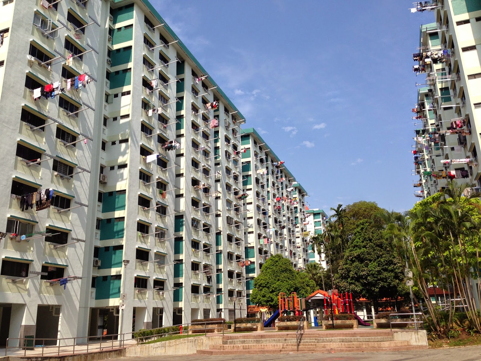
Laundry drying
Clothes on poles are typical sight in Singapore. Since aircon and electricity are expensive here, there's no sense heating up the house with the dryer. It makes for a great picture.

Through the HDB, I connect to Admiralty Road West and take a water break at Woodlands Waterfront. There's a view of the Causeway, the connecting bridge between Singapore and Johor Bahru, Malaysia.
 Heading East along the park, I take time to hit this pier. It afforded a great view of the Straits of Johor.
 The sun is out today and its freaky hot, so I'm a little embarrassed when I pull out my umbrella.
I'm heading towards the end of my walk, so I start back south through Admiralty Park. GPSs are great, but they don't tell you everything. Like in this case, where I'm walking on the scenic trail which dead ends at this prison fence.
I wrap back around and head south through Admiralty Park. Two minutes later and I'm in a mangrove.
The feeder into Sungei Cine at Admiralty Park
And seeing these signs:
 I appreciate the angry monkey driving the point home. I saw no monkeys in the park, but I kept my shiny objects in my pockets just in case.
In typical Singapore fashion, the bridge in the mangrove was under renovation, so I had a pretty big walk around to get back on track.

With it getting late and the temperature getting hotter, I decide to abandon my final destination in Admiralty and instead stop at the Woodlands town center. Here you can find the MRT as well as CausewayPoint, one of the largest shopping malls in Singapore. I could not get a good picture of it, but I liked this one leading up to it:
I'm curious what happened here.
And that's what I love about Singapore. One minute you are on the coast, the next minute you are in a jungle, and a minute later you are in a shopping mall.

On a side note: this detour was fortuitous because as I walk into the mall, I realize that I have been here many time before. In 2000, during my first tour in Singapore, my colleagues and I would frequently taxi 20 minutes from Ang Mo Kio to here, just to have a burrito at the only Taco Bell north of CBD.

As the trip ends, I get some water, cool down, and head home via MRT.

Total route: 9.65 miles. 3 hours, 05 minutes.


Sunday, 13 April 2014

Day 5: Jalan Murai to Kranji

If you think the trip to Chinese Gardens is far, the journey to Jalan Murai is much farther. By app is telling me its 109 minutes by bus. So at 8am, for the sake of time, I hop into a taxi which cuts my ride to 30 minutes. The weather is good, partly sunny and 81.

It is tough getting a taxi this morning. Strange for a Sunday, so after waiting awhile at the apartment, I walk down to Orchard and hail one. I tell the guy I want to go out into the middle of nowhere, Bus stop Lim Chu Kang Rd B31A.

On the way, we see some guys fighting outside Orchard Towers. That leads to a healthy discussion about multiculturalism, local politics, class isolation, individual vs group happiness. Its a pretty heady discussion for a Sunday morning. One thing I like about Singapore is that the drivers have a lot to interesting things to say.

Its still Qingming, so we get in a huge jam at the cemetery. 1 mile later, I'm at my stop. Here's what I see:
Lim Chu Kang Rd next to Tengah Air Base.
Boring, right? But thanks to my driver, it has a good story. This road is next to the Tengah Air Base, where most of the Singapore Air Force's front line squadron's and early warning planes are located. Note that the road has no center divider which is extremely uncommon in Singapore. The reason is that this road can also be used to land planes and other military aircraft in an emergency. There is another one out near Changi Airport on the northeast side of the country. Its a great economy of space in a country where space is limited.

Up the road a mile or so, the road narrows, going from 6 lanes to 2. It's here that the sidewalk ends and I'm walking in the grass, one side or the other depending on the twist and turns in the road.
Cyclists on Lim Chu Kang Rd
 Along this road, I see many cyclist. Its part of the Kranji Loop, a 50 km stretch covering most of the Northwest. This is a great loop for its historical significance... the Japanese began their invasion in this area in 1942... and for the relative reduction in the number of cars. A many riders know, cycling downtown can be very dangerous.

Passing by Lim Chu Kang Lane 3, I unexpectedly ran into this guy. No explanation was given.
A friendly face
 I'm now heading into farm country. Many things are grown in this part of the country.
Fresh vegetables, tropical flowers, tropical fish, crabs, frogs. I was fascinated by the frog farm but didn't want to invest the extra 2 km to find out.
Farm fresh in the Northwest
 Lim Chu Kang keeps heading north until it runs out. When it does, you arrive at this dock, near the Police Coast Guard base.
It was busy this morning. There were about 30 seats at the end of the dock and it looked like a ceremony was about to start.

I backtrack down Lim Chu Kang and took the first left onto Lane 8. Lane 8 to Lane 6c, 5, etc. All of this is farm land. On 6C, I had to stop here and get a view of the thousands of Orchids being grown under dark mesh. Lovely on a grand scale.
 I went along a few more lanes, eventually catching up to the frog farm and then this massive hydroponics garden of which this picture is just a small slice.
Exiting the "Lanes", I hit Kranji Way, and head northeast. One last picturesque farm scene, a tractor in a field. This is a picture I never expected to take in Singapore.
I'm getting back into civilization now as is evident by the sidewalks and the bus stops. I start to cross the Kranji Reservoir, but before I do, I take a stop at Kranji Beach.
The entrance to Kranji Beach
Its an unassuming beach, really not a beach at all, but its significant in Singapore's history as the place where the 27th Australian Brigade defended the coastline from Japanese invasion in Feb 1942. They ultimately pulled back as the Japanese made inroads in the west.
A picture of Kranji Beach Battle Site.
 Over the reservoir, I take Kranji Way into a more industrial area. Here, there are Granite manufacturers, Timber shops, car parts dealers. Many people are working, even on this Sunday. I watch as the workers take lunch, or a rest, and set up chairs to perform ad-hoc hair cutting by the river side.
Water reclamation in Kranji
Coming down Kranji Road to Woodlands Rd, I pass by a Water Reclamation plant. This plant and all the reservoirs are very important to Singapore's future. There have been and still are contentious battles here over the supply of fresh water. Singapore is working now to be totally water independent by 2061, a big feat.

Just up the road, I pass by the Turf Club and on to the Kranji MRT. A pretty good and interesting day.
So far, I have covered 50.7 miles in 14 hours and 48 minutes. That's halfway there. Tomorrow is an off day and I can look forward to shorter distances over the next few walks.

Total route: 11.54 miles. 3 hours, 21 minutes.


Saturday, 12 April 2014

Day 4: Chinese Garden to Jalan Murai

A couple of days of rest were needed. All wounds are healed and I'm ready to go.

Its Saturday, overcast, and about 79 degrees. I'm planning a 7am start today. As I packed my bag, a heavy downpour started. Luckily, it was brief and by 8am I was on my way.

It pretty far form Orchard to Chinese Garden. My fancy phone app says it'll take 68 minutes by bus and MRT. So, I hop in a taxi and I'm there in 20.

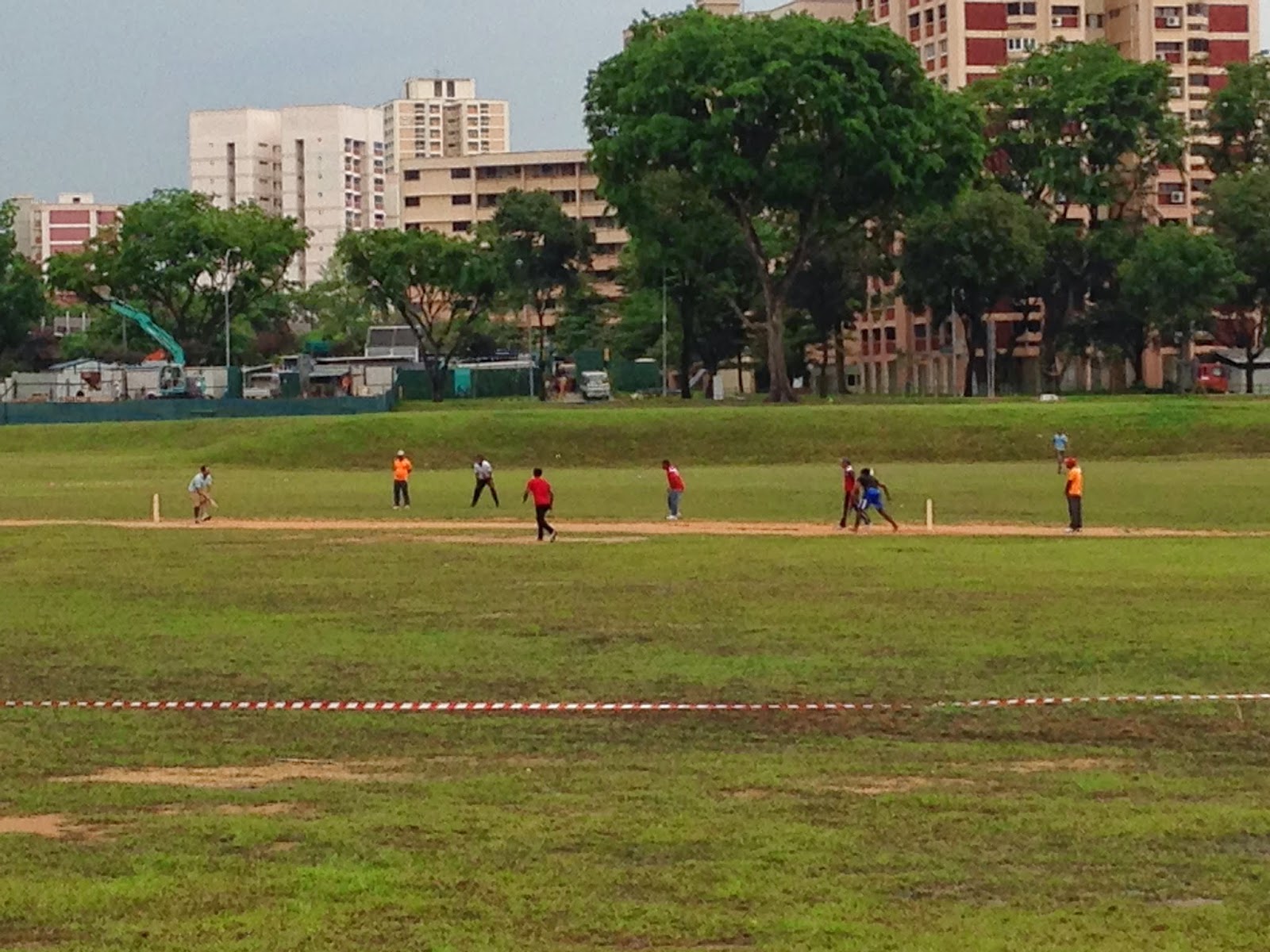
Its early, but things are already happening. In the space between the MRT station and the entrance to the Gardens, a cricket match is taking place.
Early morning cricket at Chinese Garden
The Garden opens at 6, so I continue my tour, heading to the right around Jurong Lake, over the bridge and into Jurong Lake Park. There lots of jogger and bicyclists this time of morning, but I'm stopped by these ladies, practicing some very elegant moves with swords and fans.
What appears to be Tai Chi with Taiji sword or fan
From here, I follow the park connectors along the Jurong River to Boon Lay. I'm walking behind some old landed houses here with open kitchens in the back. I enjoy hearing the families (grandparents, parent, children at the same table) talking over the their morning meal. As the river meets Boon Lay, I spot another Malaysian Water Monitor Lizard (about 3ft nose tail). I make a note never to swim there.

I'm about an hour underway on a 10 mile trip, so I stop into Jurong Point Mall to get some iced caffeine and some aircon. On the way out, I snap this picture of the overhead tracks of the Boon Lay MRT set against the local housing.
The tracks at Boon Lay
 Speaking of, Singapore has a population of ~5.4 million people (est. 2013). They have to be housed somewhere, so many communities are city-like, mixing malls, shops, schools, and housing together. The Singapore government provides residential housing called HDB flats. 85% of the population live in these flats which cater to all income classes.

I'm fond of these building in which most are painted in bold, pastel, or other interesting colors and patterns.
Block 948 HDB Jurong West
Just up the street, the geography starts to change. As I cross under the Pan Island Expressway (PIE), it becomes decidedly more green. Nanyang Technical University is on my left and trees and grass are ahead and on my right. Its telling me that I'm about to head in to the countryside.

Exiting NTU, I turn North up Jalan Bahar, a wide open 4 lane highway. A couple of miles up the road I reach the Choa Chu Kang Cemetary Complex. With space limited in Singapore, its the only cemetery left that allows burial. I wanted to keep up my pace, but I'm fascinated here. The cemetery goes on forever as you can see in this picture, looking all the way to the back.
Burial plots in the Chinese Section of the Complex
I came at a great time as it was during "Qingming" also known as "Remembrance of Ancestors". Singaporean cemeteries are typically quiet. But today there were many, many families here cleaning their ancestors graves, lighting incense, and leaving offerings of food. Near the graves were fire pits where the families burned gold paper offerings representing money for their ancestors to use in the afterlife.

I expected to spend maybe 30 minutes at the cemetery and wound up spending an hour and a half.

Singapore is multi-cultural and thus this cemetery also houses all other religions. I was particularly fond of the Muslim Cemetery very due to its bright and colorful burial plots.
Its time to wrap this thing up, so out of the cemetery and North again onto Jalan Murai, a tiny road that starts our first farms of the next leg of the journey. On this road was an organic vegetable farm as well as proof that eggs produced in Singapore are actually grown in Singapore.
At the end of the road, this my first back road, I turn left onto Lim Chu Kang Road and end my journey by the first bus stop.

Picking up the bus, I head home feeling pretty good. I note that there should be more overcast days in this journey.

Total route: 11.70 miles. 3 hours, 24 minutes.


Wednesday, 9 April 2014

Day 3: HawPar Villa to Chinese Garden

Its a banner day! In 3 days, I've covered 27 miles. That's a marathon plus in 8 hours. I'm no athlete, so I count that as pretty good. In celebration, I'm taking tomorrow off.

So, onto Day 3, which started out as a great and ended in exhaustion.

The morning was cool: 79 degrees at 8:00 am and a little bit of a breeze. I felt pretty good, just tight muscles. I was out the door early, picked up the 7 bus to Dhoby Ghaut, and then retraced the MRT route I took to get home yesterday. You can see me here, looking pretty happy:
At the entrance to Haw Par Villa
Continuing yesterday's journey, I'm again walking along West Coast Highway, a 3-laner that goes around the southwest of the island.
I add this pic here for a reason. Even though this a major road, you can really see how nice it is. These overpasses are frequent, colorful, and make all parts of the island completely accessible. On this road, I thought I was going to be out on my own. I was surprised to see that there's neighborhoods just over on the left and many people going about their day.

Then just ahead, I duck into West Coast Park. Its bigger than I expected and plenty shady. There were quite a few things to see here:
First note the irrigation. In the rainy season in Singapore, it can really come down in buckets. All that water has to go somewhere. Throughout the country, small channels like this one lead to bigger ones, which lead to major ones, which end in the surrounding waters. It's really amazing that between this and the sun, the ground can be completely dry 30 min or so after a major storm.

Next, I pop out to the coast and take in some more views of container ships, refineries, and yachts.
This catches my eye:
Local fishing boats and a beach. I did not believe that there was a single natural beach in Singapore, well maybe a few small ones in the north. Back along the tree line, fishermen were busy putting together their traps for the day's work, just like you can see in Malaysia and Thailand.

In the far back of that picture, the road runs out and I follow the trail back inland. So, I'm just walking past "Marsh Pond", when "Whoa!!":
I see this guy. I think, is it a croc? It's 3 feet long, nose to tail. Pretty cool. I immediately text my wife to let her know my peril. Turns out, its a Malay Monitor Lizard, one of the largest lizards in the world. I had reason to be afraid. I put my palms out flat and slowly back away.

North of West Coast Park, I say a little good bye to all the shipping containers, well aware that I will see more. I decide to head left across the Pandan River and then what I think will be a relaxing stroll by the Pandan Reservoir.
Pandan Reservoir near Jurong East
The reservoir is the largest in Singapore serving up water to the businesses that surround it. I pop up on the southeast side and make it for a miles or so. That was enough, because while beautiful, it was completely un-shaded and the sun was hot. I quickly finished my first bottle of water. As soon as I could, I detoured off the west side.

And it didn't get  better. That's because we were headed into Jurong, designed as an industrial area. It contains many, many building that look like this:
 Now, I knew this part of the journey was going to be boring and long. But its getting on 9:45 now its both hot and humid. The weather crept up on me. Worse, as its an industrial area, there was little consideration for trees and places to stop for a rest. So, what do you do when you get down, get out your umbrella:
Jim and his 'Caring for Cambodia' umbrella. The smile is just a ruse.
So, its another 2 mile slog through industrial parks, until I finally make it to this hawker center:
Time for a break, some cold water, some Pau and a repositioning of the shoes which are starting to hurt the feet.  I'm short on steam at this point, so I make one final push to here:  The ChineseGarden.
 I stopped in here with the family back in October and it was lovely, a great spot to take the kids. The Ru Yun T'a Pagoda in the picture above is climbable and offers some fantastic view. I did not make the attempt today.
 
At the end of my journey, I made one last stop at the Rainbow Bridge that connects the Chinese and Japanese Gardens to rest up.
Just around the corner was the Chinese Garden MRT, the end of my trip. In a well thought out decision, I decided to nix the MRT and take a taxi home.

Total route (walking and slogging): 10.23 miles. 3 hours flat.